Cape Breton’s landscape is a puzzle of glacial till, fractured sedimentary bedrock, and coastal saltwater margins that make subsurface characterization anything but straightforward. When drilling alone cannot resolve what lies beneath, electrical resistivity and Vertical Electrical Sounding (VES) provide a continuous profile of the ground without disturbing sensitive terrain. Our laboratory team has run hundreds of arrays across the Bras d’Or Lake watershed and the Sydney coalfields, where abrupt lateral changes in clay, sand, and shale demand high-resolution geophysical data. We deploy Wenner and Schlumberger configurations tailored to the target depth, feeding the results directly into geotechnical models that guide excavation planning, groundwater assessment, and foundation design. For projects near the coast, where saltwater intrusion can mask lithological boundaries, a seismic refraction survey often complements the resistivity dataset to resolve velocity contrasts that conductivity alone may miss.
A well-constrained VES profile reveals the contact between glacial till and bedrock with a precision that can reduce the number of confirmation boreholes by 30 to 40 percent.
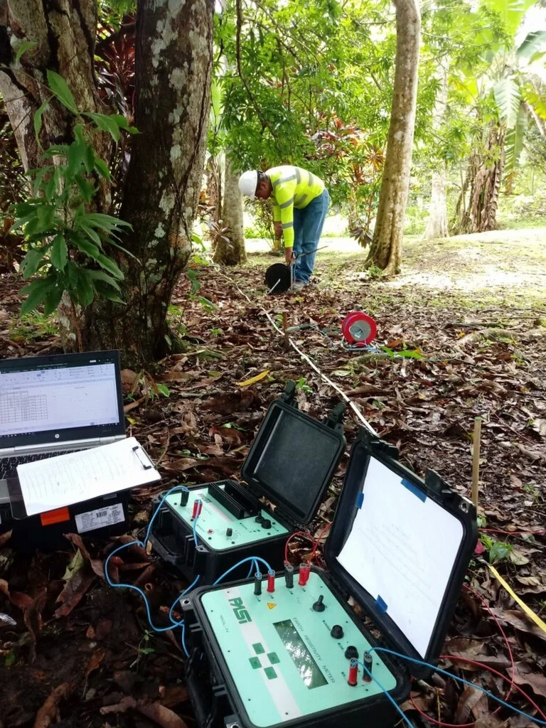
Process and scope
Local considerations
NBCC 2020 emphasizes the need for site-specific subsurface data in regions with variable overburden, and few places in Nova Scotia exemplify this variability like Cape Breton. Skipping geophysical reconnaissance in areas underlain by the Windsor Group evaporites can lead to undetected cavities or dissolution zones that compromise foundation stability; resistivity profiling clearly identifies these low-resistivity, water-filled voids before excavation begins. Similarly, along the Sydney Harbour shoreline, post-industrial fill and buried waste layers create a conductive signature that VES can delineate in plan and depth, allowing engineers to design remediation strategies with accurate volume estimates. The other risk is misinterpreting a saturated clay layer as bedrock when relying solely on borehole refusal; a resistivity curve that shows a gradual transition from 20 ohm-m to 200 ohm-m over several meters indicates a weathering profile, not a sharp contact, and this distinction changes the required pile embedment depth significantly.
Applicable standards
The geophysical investigation complies with ASTM D6431-18, which offers a standard protocol for subsurface characterization employing the direct current resistivity method, in conjunction with NBCC.
Related services
Vertical Electrical Sounding (VES)
1D resistivity depth profiling at discrete locations to map layer thicknesses, bedrock depth, and groundwater tables beneath proposed building pads or embankments.
2D Electrical Resistivity Tomography (ERT)
Continuous resistivity cross-sections along linear corridors such as pipeline routes, highway alignments, or dam foundations, resolving lateral changes with electrode spacing down to 2 meters.
Groundwater & Saltwater Intrusion Mapping
Identification of freshwater-saltwater interfaces in coastal aquifers using resistivity contrasts, essential for well siting and environmental baseline studies around the Bras d’Or Lake.
Cavity & Subsidence Detection
Targeted surveys over evaporite karst terrain to locate dissolution features, abandoned mine workings, or void-prone zones within the Windsor Group formations.
Typical parameters
Questions and answers
What depth can a VES survey reach in Cape Breton’s glacial soils?
In the glacial tills and weathered bedrock typical of Cape Breton, our standard Schlumberger array reaches depths of 40 to 60 meters, though this depends on the maximum current electrode spacing and the resistivity contrast between layers. In conductive marine clays, the penetration depth is shallower because the current dissipates more quickly; we adjust the array geometry and transmitter power accordingly to maximize the signal-to-noise ratio. For deeper targets, such as regional aquifer mapping, we extend the AB/2 spacing beyond 100 meters, which can push the investigation depth past 80 meters provided the subsurface is sufficiently resistive.
How much does an electrical resistivity survey cost in Cape Breton?
Can resistivity surveys work in areas with buried utilities or reinforced concrete?
They can, but the presence of buried metallic pipes, reinforced concrete foundations, or overhead power lines introduces conductive or inductive noise that distorts the resistivity readings. In Cape Breton’s urban zones such as downtown Sydney or Glace Bay, we perform a utility clearance scan first and then adjust the electrode layout to move the array away from known interference sources. The inversion software can also model and subtract the signature of a known conductive feature if its position is well-documented, though this requires careful parameterization. When the site is too congested, we may recommend complementing the resistivity survey with a seismic method that is less sensitive to metallic objects.